These guidelines have been prepared to simplify and standardise application and computation of floodway safety requirements in the greater Melbourne region. They're intended for use by the subdivisional development industry, local government and water management agencies including ourselves.
The guidelines have been largely adapted from the laboratory research results reported by Keller and Mitsch (1995), tempered by experiences of the authors and other practitioners.
The guidelines apply to artificial or modified drainage systems in greenfields, infill and redevelopment situations, for which the design floodway use couldn't be expected to be clearly recognisable by the lay observer.
Hence the guidelines don't cover those systems which by their visual nature and setting are clearly discernible to be open waterways likely to be subject to flooding from time to time.
All natural waterways and flood plains are thereby specifically excluded.
Methodology
Floodway hydraulics may be determined using Manning's Equation. Unless uniform flow conditions can be confidently predicted, steady-state backwater programs such as HEC-RAS shall be used to compute depths and velocities. Safety criteria are normally expressed in terms of the product of velocity and depth of flow but in most applications limits on either or both of velocity and depth may also apply.
For the purposes of these guidelines the following parameter values and definitions will apply:
-
Manning's 'n' = 0.020 for streets used as floodways
-
Manning's 'n' = 0.030 for well maintained grassed floodways in easements possibly containing sparse tree plantings on the verges, in urban areas
-
Manning's 'n' = 0.035 for all other formed grassed floodways containing sparse tree and shrub plantings in urban areas
-
Vav = average cross-sectional velocity for area of the full floodway section contributing to flow (m/s)
-
Vbank = average cross-sectional velocity in the area of the bank zone that contributes to flow (m/s)
-
Backwater pools and / or fringe pondage areas are not considered to contribute to flow
-
dav = average cross-sectional depth calculated as cross-sectional area contributing to flow/top water width (m)
-
dmax = maximum flow depth of the floodway (e.g. the gutter invert in a road floodway or car park)
-
act = actual depth of the floodway at any reference point
-
For road floodways, the top water width shall be the road reserve width or actual water surface width, whichever is the lesser. No cross-section area beyond the adopted top water width shall be included in the calculations
-
The design floodway flow for the recommended safety limits shall normally be the 100 year ARI peak flow, less the effective capacity of any related underground system
-
Where significant inlet blockage problems could reasonably be expected to occur with the fully constructed drainage system during major flood events, the effective capacity of the underground system shall be considered to be 80% of its potential capacity
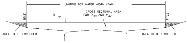
Figure A1 Road Floodway Definitions
Floodway criteria
Residential streets used as floodways
For streets in residential areas which are designed to function as integral components of the major drainage system when pipe capacities are exceeded, velocity and depth limits shall be dictated by safety of children first and stability of cars second. Car stability is significant because of the potential for increased flood levels due to floodway blockage.
It's considered appropriate for an allowance to be made for variation of depth over the road cross-section and the typically localised nature of the highest hazard zone which is concentrated around the gutter line. This allowance has been achieved through use of the cross-sectionally averaged depth in lieu of actual gutter depth.
Recommended safety limits
For continuously grading streets: Vav.dav <= 0.35 m2/s, and dav <= 0.30m
(for 1:200 slope and 16 m reserve width, Vav.dav will control with
dmax = 0.42 m)
For undulating streets
Where the road longitudinal section is formed as a series of dips and crests (more usual in flat terrain) with a nominal grade applied along the crests, the limits shall be:
Crests - Vav.dav <= 0.35 m2/s, and dav <= 0.30m
Dips- Vav.dav <= 0.30 m2/s, and dav <= 0.60m
(For 1:200 pavement slope, 16 m reserve width and 1: 800 slope across crests, the dips will limit allowable peak discharge with dmax <= 0. 8 m)
Backwater analyses shall be provided to verify conditions with such road formations.
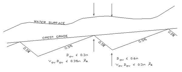
Figure A2 Undulating road floodway
Industrial streets used as floodways
For streets in industrial areas which are designed to function as integral components of the major drainage system when pipe capacities are exceeded, velocity and depth limits shall be dictated by safety of adults and stability of cars. Small children wouldn't normally be expected to be present in such areas.
The stability of cars is more critical according to the results of Keller and Mitsch (1995). It's considered appropriate for an allowance to be made for variation of depth over the roadway cross-section and the typically localised nature of the highest hazard zone which is concentrated around the gutter line. This allowance has been achieved through use of the cross-sectionally averaged depth in lieu of actual gutter depth.
Recommended safety limits
The limiting Vav.dav may be determined by linear interpolation between the following limits:
Vav.dav <= 0.60 m2/s, for dav <= 0.1 m
Vav.dav <= 0.80 m2/s, for dav =0.2m
Vav.dav <= 0.35 m2/s, for dav >= 0.3 m
Where the road longitudinal section is formed as a series of dips and crests (more usual in flat terrain) with a nominal grade applied along the crests, dav shall not exceed 0.60 m at the low points. Backwater analyses shall be provided to verify conditions with such road formations.
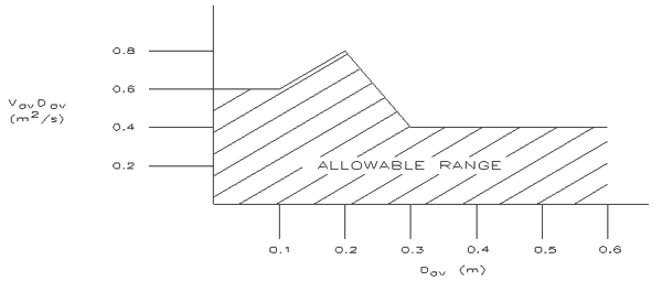
Figure A3 road floodways - Industrial areas
Streets crossed by floodways
For streets which are crossed by open floodway systems, lateral stability of cars may become more critical as depth increases. Firstly, because of the general unforeseen nature of the primary hazard. Secondly, for the possibility a vehicle and its occupants may be swept off the road into an area of far greater hazard downstream.
Local hydraulic conditions will dictate actual velocity and depth in the pavement area/s. As these conditions may vary greatly between sites as well as across the road formation at any particular site, a full understanding of the site-specific hydraulic controls is essential. Where the road formation itself doesn't form the hydraulic control across the range of flows being considered, a backwater analysis will be required.
Embankment crossings
The following limits apply to floodway crossings of any road which effectively exists as an embankment control relative to the levels of the downstream floodway but which isn't specifically designated as a floodway crossing and fitted with appropriate signage and flood depth boards.
Recommended safety limits
Vav.dav <= 0.35 m2/s along footpath alignments (existing or hypothetical), and dmax < 0.30 m measured at both the downstream back of kerb and the pavement centreline.
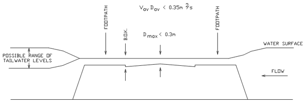
Figure A4 Floodway discharge controlled by road crossing embankment
Low point depression crossings
For crossings in locations where downstream hydraulic controls force deep flooding at slow velocities, there's a likelihood of higher property damage costs, but depth restrictions may be relaxed.
Recommended safety limits
Vav.dav <= 0.35 m2/s along footpath alignments (existing or hypothetical), and dmax <= 0.8 m measured gutter invert.
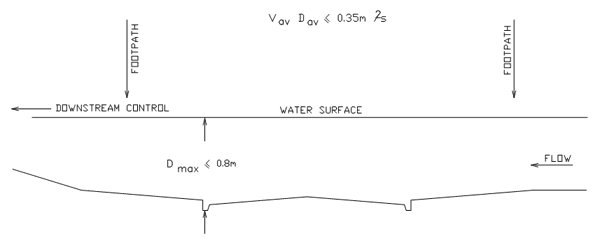
Figure A5 Floodway crossing low point depression
At-Grade crossings
For at-grade crossings where one route is designed to act as a floodway, child and car stability objectives are generally similar.
Recommended safety limits
Road intersections: Vav.dav <= 0.35 m2/s and dav <=0.30 m (using the cross-section at kerb return on the downstream side of the intersection on the floodway route), subject also to dmax < 0.30 m measured at the centreline road crown intersection point.
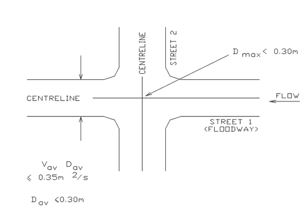
Figure A6 Road intersections (At Grade)
Roads crossing floodways: Vav.dav <= 0.35 m2/s and dav <=0.30 m along footpath hypothetical) and along the road pavement centreline, taking into account any skew in the floodway crossing.
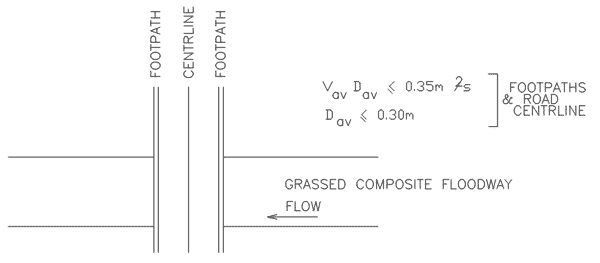
Figure A7 Road crossing floodway (At Grade)
For any road crossed by a floodway, the use of other design measures should be encouraged to control approach speed and/or to alert the driver to possible changing conditions. These could include variation of pavement form, provision of slow points, and use of stop/give way signs on crossroads.
Grassed floodways in drainage reserves
In dedicated drainage reserves, the primary criteria should be appropriate to the safety of children, but with provision for increased depth and velocity of flow towards the centre of the floodway where an avenue for retreat is provided by cross-sectional design.
Full child safety is to be maintained out to depths of at least 0.4 m on both banks wherever free access is available. (E.g. full child safety will be provided to act = 0.4 m out into a grassed floodway channel grading at 1 in 150 with batter slopes of 8:1 (H:V)).
For act > 0.4, the V*d ratio may increase without the need for provision of safety barriers, provided that no steepening of the bank slopes occurs and a limit is placed on maximum channel velocity.
Recommended safety limits
Vbank.dact <= 0.35 m2/s and act <=0.40 m
and Vav <= 1.5 m/s for act > 0. 4
Grassed/composite floodways in easements through residential or commercial property (peripheral car parking only)
The primary criteria should be appropriate to the safety of children, but with provision for increased depth and velocity of flow towards the centre of the floodway where an avenue for retreat is provided by cross-sectional design and a barrier to accidental access into deeper zones is provided. As for the drainage reserve case, full child safety is to be maintained out to depths of at least 0.4 m on both banks wherever free access is available.
For act > 0.4, the V*d ratio may increase provided that no steepening of the bank slopes occurs, a barrier is provided to deter accidental access, and maximum velocity is limited.
Recommended safety limits
Vbank.dact <= 0.35 m2/s and act <=0.40 m
Barrier at act = 0.4 m
Vav <= 1.5 m/s for act > 0. 4
The barrier could be bollards and chain, timber posts and rail or similar. It doesn't have to prevent access, but it must be clear above water surface level.
Any driveways or car park areas aligned parallel to the flow direction shall be located where act <= 0.30 m.
Any driveway or roadway crossings of the floodway shall conform to the safety requirements set out in Section 3.3 above.
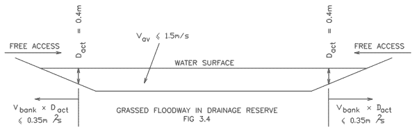
Figure A8 Grassed/Composite floodway in easement in residential/commercial Property
Grassed/composite floodways through residential or commercial property car park zones
The primary criteria should be appropriate to the safety of children, but with assured stability of parked cars. Property damage objectives conform with desired floodway operation characteristics in this instance because of the potential blockage effects if cars are de-stabilised and moved during the flood.
The stability of cars generally controls at depth greater than 0.30 m.
Recommended safety limits
Vav.dav <= 0.35 m2/s and dav <=0.30 m
and dmax < 0. 40 m
No barriers required.