Melbourne Water is working with local councils to update flood information across Greater Melbourne. This helps us better understand the risk of current and future flooding, so we can build a safe and resilient city for today, tomorrow and for generations to come.
Improving flood information, through sophisticated flood modelling, is a significant program for Melbourne Water being rolled out over the next few years.
Sign up to be notified when your local flood maps are available for feedback
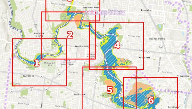
We’re working with local councils to update flood maps across Greater Melbourne. The maps show areas predicted to flood, now and in the future – so we can plan for our changing urban landscape and weather.

Why flood information is important
Flood information helps us understand how best to prepare for flooding and minimise its impacts. It is used by the state government, local councils, developers and businesses, as well as the community.
It ensures new houses and developments are built in safer locations and designed to withstand floods. It also helps us prioritise flood infrastructure upgrades in areas of highest risk to the community.
Flood models don’t create flood risk – they help us to better understand the emerging risks that Melbourne now faces.
Program timeframes
The Greater Melbourne Flood Information Program is being rolled out across the city, in partnership with local councils.
Melbourne Water will review flood models every 5 years and update them every 10 years, using sophisticated technology that allows us to do modelling more regularly. Any major flood or significant changes in the catchment will also trigger a review of our flood models.
Understanding your flood risk
You don’t have to wait for new flood information to find out how to prepare for a flood.
It’s important for everyone to be prepared, no matter where you live or if you’ve been impacted by floods before:
- The VICSES website has actions you can take to prepare for a flood.
- Our planning and building information has guidance if you’re renovating or redeveloping property in a flood-affected area.