Melbourne’s water supply mainly comes from reservoirs, with top-ups from the Victorian Desalination Plant. Our reservoirs draw much of their water from protected water catchments. These produce some of the highest-quality drinking water in the world.
What is a catchment?
A water catchment is an area of land that collects water when it rains. Some of it ‘runs off’ the surface of the land, flowing down into the rivers and creeks that feed our reservoirs. The rest evaporates, is absorbed by plants or seeps into the soil.
The amount of runoff changes with the seasons, depending on how wet the soil is. For example, only about 10% of summer rainfall turns into runoff because the dry soil acts like a sponge, soaking up the rain before it can flow into streams.
Our catchments
Melbourne’s water supply catchments include:
- 80,500 hectares national parks, managed by Melbourne Water and Parks Victoria
- 68,500 hectares state forest, managed by the Department of Energy, Environment and Climate Action (DEECA)
- 7,900 hectares Melbourne Water freehold
- 4,100 hectares Crown land vested to Melbourne Water
- 2,000 hectares private freehold
The total catchment area is approximately 163,000 hectares, including both protected and open catchments.
Protected catchments
Melbourne is one of the few cities in the world with protected catchments, which provide over 65% of our drinking water. These are located north and east of our city, often in national parks and state forests where people are generally not allowed to enter. Limiting public access protects water quality at its source, meaning this water needs very little treatment.
Open (on-stream) catchments
Some of our water comes from on-stream catchments – such as Tarago, Yan Yean and Sugarloaf. These areas include a mixture of Melbourne Water vested land, privately-owned farmland, state forests and national parks.
Some of these areas allow activities like picnics and have walking tracks. A very small proportion of catchments (about 0.2%) are open to timber harvesting from December to April, following government regulations.
Water from open catchments is fully treated at our Winneke and Tarago water treatment plants. This ensures it meets the same quality requirements as water from protected catchments.
Why protect our catchments?
Our protected catchments are a fantastic legacy of our city’s planners. Since the 1800s, this has been a key part of the way we manage drinking water quality – helping avoid contamination and protect the health of our community.

Every activity in a protected catchment poses a major risk to our drinking water supply. These include:
- untreatable pathogens carried by humans, livestock and pest animals
- contamination from camping and toileting
- poo or urine from pets
- sediment from disturbing soil around the catchment
- rubbish left behind
- pollutants carried by shoes or bike tyres
- disease from animal carcasses
- bushfires.
Accessing our catchments
We want to support people to enjoy Victoria’s vast natural spaces. But this must be balanced with protecting important areas, like designated water supply catchments, from public access. Limiting access to our protected catchments is more effective and less costly than fully treating all our drinking water, helping keep it safe and affordable now and into the future.
We protect our catchments through regular security patrols, CCTV and supplementary surveillance technology.
Unauthorised access and activities within our protected catchments may be fined or prosecuted under the Water Act 1989 (Vic).
There are seasonal road closures in state forest areas. Restrictions generally apply from 1 May to 30 November.
- List of catchments and access restrictions
-
Catchment Access details Armstrong - No entry into protected water supply catchment. Offenders may be prosecuted.
- Vehicles permitted on public roads:
- Marysville Woods Point Road
- Reefton Spur Road
- Cambarville Road leading to recreation site
- Pedestrians permitted at:
Cardinia - No entry into protected water supply catchment. Offenders may be prosecuted.
- Entry permitted to the following areas, managed by Parks Victoria:
- Cardinia Reservoir Park
- Aura Vale Lake
- Dam Wall Walking Track.
Cement - No entry into protected water supply catchment. Offenders may be prosecuted.
- Vehicles permitted on Acheron Way public road
Silvan - No entry into protected water supply catchment. Offenders may be prosecuted.
- Entry permitted to Silvan Reservoir Park, managed by Parks Victoria.
Greenvale - No entry into protected water supply catchment. Offenders may be prosecuted.
- Entry permitted to Greenvale Reservoir Park, managed by Parks Victoria.
O’Shannassy - No entry into protected water supply catchment. Offenders may be prosecuted.
- Vehicles permitted on public roads:
- Marysville Woods Point Road
- Road 8.
- Pedestrians permitted at at recreation sites and O’Shannassy Aqueduct Trail (Road 18).
For details, view Parks Victoria’s information on Yarra Ranges National Park.
Upper Yarra - No entry into protected water supply catchment. Offenders may be prosecuted.
- Entry permitted to Upper Yarra Reservoir Park, managed by Parks Victoria.
- Vehicles permitted on public roads:
- Warburton Woods Point (Reefton Spur)
- Nine Mile Road
- Toorongo Road
- 40 Mile Break/Road 20 (seasonally closed).
- Pedestrians permitted at recreation sites and Upper Yarra Walking Track (40 Mile Break/Road 20/Toorongo Road).
Maroondah - No entry into protected water supply catchment. Offenders may be prosecuted.
- Entry permitted to Maroondah Reservoir Park, managed by Parks Victoria.
- Vehicles permitted on public roads:
- Maroondah Highway
- Monda Road
- Donna Buang Road
- Badger Weir Road
- Donnelly’s Weir Road.
- Pedestrians permitted at recreation sites and walking tracks.
For details, view Parks Victoria’s information on Yarra Ranges National Park.
McMahons - No entry into protected water supply catchment. Offenders may be prosecuted.
- Vehicles permitted on public roads:
- Muddy Creek Road
- McCarthy Spur Road
- Boundary Road (seasonally closed)
- Pedestrians permitted at recreation sites and Upper Yarra Walking Track (Boundary Road).
Thomson - No entry to inner catchment. Offenders may be prosecuted.
- Entry to outer catchment permitted with restrictions determined by the Forest (Recreation) Regulations.
- Entry permitted to:
- publicly accessible roads
- vehicle-based day visitors
- multiple walking tracks
- foot-based camping (with restrictions) on the Australian Alps Walking Track and Upper Yarra Walking Track.
- Seasonal road closures in place from 1 May to 30 November each year.
Starvation - No entry into protected water supply catchment. Offenders may be prosecuted.
- Vehicles permitted on public roads:
- New Turkey Spur Road
- Brahams Road
- Starvation Creek Road
- Muddy Creek Road
- Big Creek Road
- Ada River Road.
Sugarloaf - Limited access to the public for recreation:
- licenced sailing activities permitted on reservoir (Sugarloaf Sailing Club), excluding kayaking or entering the water (e.g. swimming)
- limited lure-based shoreline fishing in designated areas (no live bait) – details on the Getfished website
- accessible public walking track (no dogs allowed)
- no camping or fires.
Tarago - No entry to inner catchment. Offenders may be prosecuted.
- Entry to outer catchment permitted with restrictions determined by the Forest (Recreation) Regulations.
- Entry permitted to:
- publicly accessible roads
- vehicle-based day visitors
- Seasonal road closures in place from 1 May to 31 October each year.
Wallaby Creek - No entry into water supply catchment area. Offenders may be prosecuted.
- Entry permitted to Toorourrong Reservoir Park, managed by Parks Victoria
- Vehicles permitted on public roads:
- Whittlesea–Yea Road
- Road 1 (Mt Disappointment Road to Cottrell Road)
- Pedestrians permitted at recreation sites and Silver Creek Walking Track.
Yan Yean - No entry into water supply catchment area. Offenders may be prosecuted.
- Entry permitted to Yan Yean Reservoir Park, managed by Parks Victoria.
- Vehicles permitted on public roads:
- Arthurs Creek Road
- Ridge Road
- Coombs Road.
You may also like...
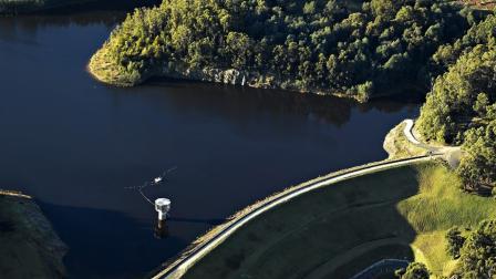
Water storage reservoirs
Get to know Melbourne’s 10 major water storage reservoirs, which help secure our water supply now and into the future.
Desalination
The Victorian Desalination Plant provides a reliable source of water in the face of challenges like population growth and climate change.

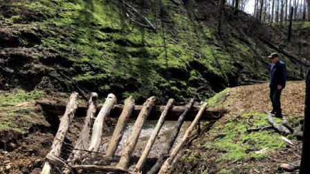
Debris flow protection after bushfire in our catchments
Case study: We are trialling structures that can mitigate debris flows into our water supply catchments after bushfires.
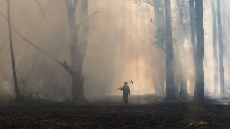
Bushfires and our water
Bushfires in our catchments impact the quality and quantity of our water supplies. We play a critical role in protecting Melbourne's drinking water from bushfires.