Labelled the ‘backbone’ of Werribee, the Werribee River is the largest waterway on the long plain west of Port Phillip Bay. It originates in the Wombat State Forest on the Great Dividing Range, and flows for about 110 kilometres south-east to the bay.
The river has a rich history, and its surrounds offer unique access to Victoria’s volcanic plain outcrops, bedrock, and gorges – as well as beautiful areas of native grasslands and river red gums. Its value as a natural asset is reflected in local community’s care for it.
Get to know the river:

History

The Werribee River forms the natural boundary between the lands of the Woi Wurrung and Boon Wurrung peoples. Many fish traps, artefacts and burial sites can be found along the river’s banks, evidence of large campsites.
The river has had at least four names: ‘Arndell’, named in 1834 by explorers Hume and Hovell after the latter’s father-in-law; ‘Peel’ and then ‘the Ex’, named by surveyor John Helder Wedgeb, who rediscovered the river in 1835. Its current name comes from the Aboriginal words Weariby (spine) and Yallock (stream), with the spelling later changed to Werribee.
Europeans settled in the area in the mid-1830s. Within a decade, the river was the scene of conflict between the colonisers and the Wathaurung people. In 1836 a squatter and shepherd were speared to death near Mount Cottrell, resulting in John Batman leading a punitive party that shot and killed at least 10 Aboriginal people.
The village that later became Werribee was proclaimed in 1850, and declared a municipality in 1862. Farmers moved into the area in the 1890s, establishing dairying and agriculture, and an irrigation scheme was established in about 1910 to produce vegetables.
Natural features

The Werribee River estuary forms the eastern boundary of a large wetland, listed as significant under the Ramsar convention. It supports environmental values like plants and animals – especially waterbirds – as well as having cultural, educational, tourism and scientific significance.
The catchment’s geology is dominated by basalt plains. The plains near Melton and Werribee form part of Victoria’s western volcanic plains grassland ecosystem, which lies in the rain shadow of the Otway Ranges. They are the driest area south of the Great Divide in Victoria, with annual rainfall of about 450 millimetres.
Only one-quarter of the catchment retains natural forest elements. Two-thirds has been cleared for agriculture, particularly dry land grazing, and a significant proportion has seen urban development – including Werribee, Melton and Bacchus Marsh. Considerable areas are also used for open space and recreation.
Wildlife
Some people say Werribee and its surrounds are second only to Kakadu National Park for birdwatching – at least 190 species can be found throughout the year!

A plethora of native plants and animals inhabit the river and its banks, and wildlife has flourished thanks to revegetation projects and the introduction of conservation areas. Here are some of the species you can see in their natural surrounds:
- Fish: the river supports rich and diverse groups of fish. Several species of recreational and commercial importance are found in the river estuary, such as black bream, King George whiting, yellow eye mullet and trevally, though overfishing remains a key threat.
- Birds: a diverse population of native and migratory species can be found along the river, including the mighty wedge-tailed eagle and splendid peregrine falcon. Our nearby Western Treatment Plant provides a haven for up to 65,000 birds at any one time, including more than one-third of Australia’s species, and migratory birds that travel from as far as Alaska, Siberia, China and Japan.
- Frogs: the frog species living among the river’s diverse habitats enjoy varied lives: some are loyal river dwellers; others divide their time between the water, wetlands and land; and others spend most of their life burrowing underground.
- Mammals: the river is home to six species of bats – including Gould’s wattled bat and the white-striped freetail bat – which roost in tree hollows during the day. Other iconic mammals are the black wallaby, common wombat and platypus, which is classified as a regionally-significant species.
- Reptiles: about 10 reptile species inhabit the river. A large proportion are skinks; others include dragons, geckos, blue-tongue and legless lizards, and the common long-necked turtle. Three protected snake species known to the area are the little whip snake, eastern brown snake and tiger snake.
- Waterbugs: the many species of aquatic insects found in the river are influenced by the region’s geology, which affects water chemistry and stream bed material.
- Plants: more than 130 species of flora are found along the river, including black, gold dust and narrow-leaf wattle, tree violet and native grasses. Plants help maintain the river’s vast ecology. Trees provide homes and nesting places for birds and mammals, while also providing an important food source.
For an in-depth look at plant and animal species you might find, view our wildlife guide:
Places to visit
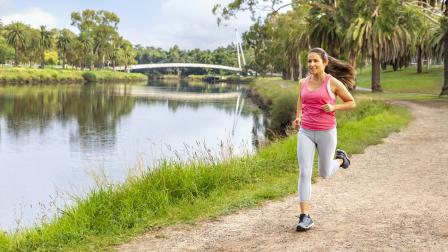
The Werribee River is great for exploring – offering an array of outdoor opportunities and extensive trail network with views of native flora and fauna. Birdwatching is a popular activity, as is fishing, with canoe and boat-launching facilities at the Werribee South Boat Ramp and Riverbend Historical Park. From Tarneit to Werribee, the Werribee River Trail winds beside the river.

The river can be accessed at several locations:
- Riverbend Historical Park (Werribee) – this reserve is an enjoyable setting for a picnic or a leisurely stroll along the network of cycling and walking trails. The nearby diversion weir was built in 1910 to supply water to the Werribee South market garden region.
- K Road Cliffs (Werribee South) – known for their iconic sculptural red clay formations, the cliffs offer habitat for migratory birds, a much-loved local fishing spot and great views.
- Werribee River Park (Cocoroc) – this 260-hectare park on the west bank of the river provides a natural setting to relax or explore its beauty. The park is part of a RAMSAR site that protects habitat for migratory birds.
To find out more about how you can explore the Wirribi Yaluk (Werribee River) have a look through the River Guide, which is a fantastic resource for anyone interested in exploring this beautiful and culturally rich area.
Protecting the river

The Werribee River is in moderate condition overall. Streamflow is a major issue, given the catchment’s location in a comparatively low rainfall area, and reduced flows are worsened by the impacts of climate change.
Land clearing and urbanisation are also challenges – contributing to widespread erosion, increased nutrient levels and salinity, and loss of habitat for aquatic life.
Community champion: John Forrester, Werribee Riverkeeper
‘I’ve had a life-long interest in the natural world and through friends I discovered the Werribee River Association, which was a small but very active group when I joined in 1993. Together with other interested local groups, we have taken a leading role in activities to care for the Werribee River such as revegetation programs, rubbish removal, research into the flora and fauna and the overall promotion of the river and its environment.
It’s important to recognise this fantastic natural resource and have all levels of government develop an integrated approach to securing solid outcomes for this river with the community.
‘The river faces some real challenges heading into the future. We need to better coordinate our resources and planning to ensure appropriate land use and urban development near the river. My hope is for a joint vision shared by waterway and other managers and groups caring for this river, so that we can all work for a common purpose.’
You may also like...
Rivers and creeks
Rivers and creeks are central to everyday life, sustaining a complex ecosystem of plants and animals – and providing natural spaces for people to enjoy. Get to know some of Melbourne’s major waterways and the vital role they play.
Grants
Learn about grants available to support innovation, liveability and collaboration across water management, and improve river health.
View annual progress towards 10-year targets for waterways in the catchment, as set out in the strategy.