Melbourne Water manages essential water and sewerage services for the region. We plan and deliver major infrastructure that supports a secure, resilient and sustainable water system for current and future generations.
What we’re doing
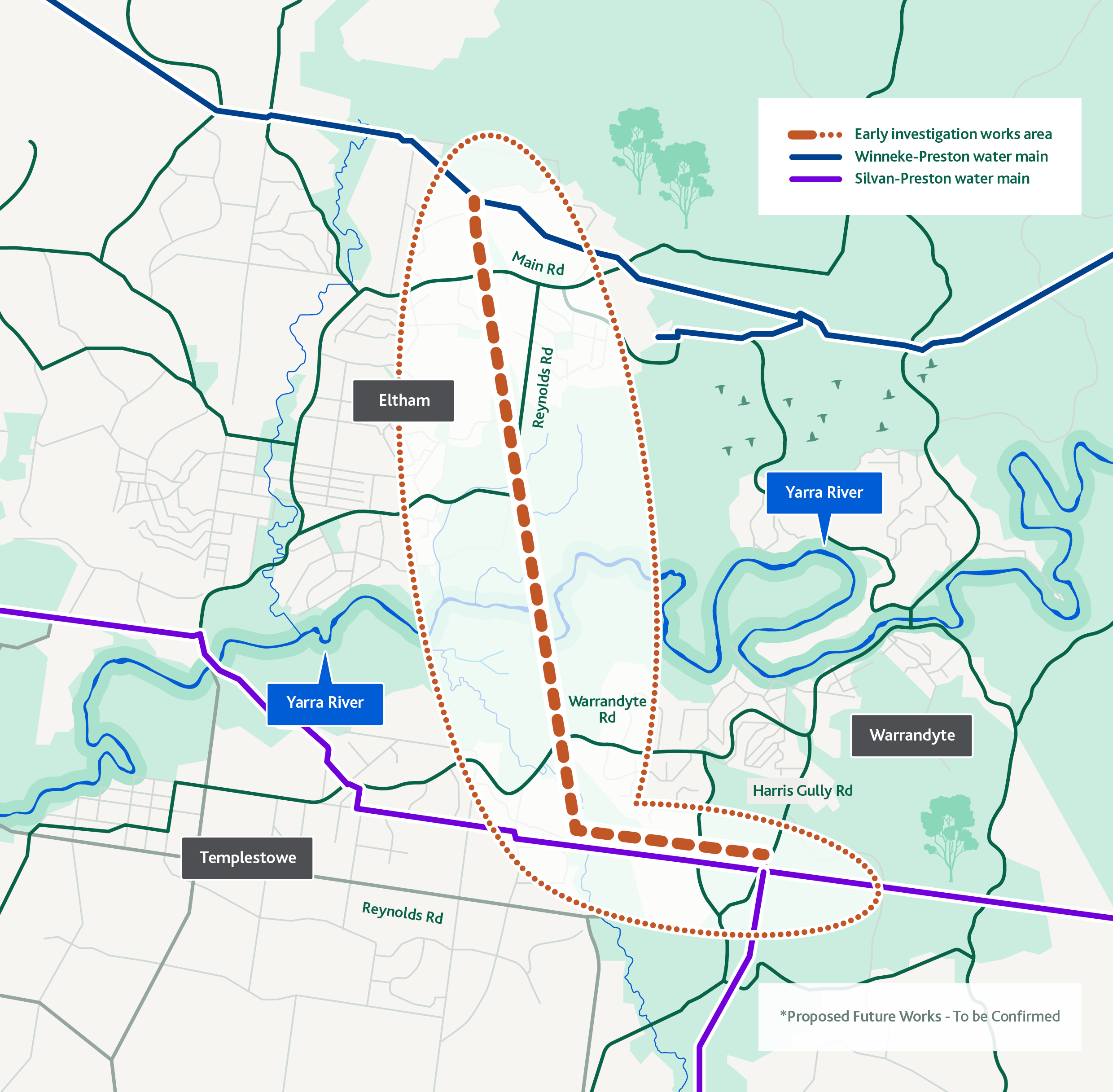
We’re planning a new underground drinking water pipeline that connect the Winneke-Preston Pipeline at Parsons Road, Eltham to the Silvan-Preston Pipeline at Harris Gully Road, Warrandyte. This new 10km pipeline will:
-
help support a reliable water supply
-
improve our ability to better manage drought, heatwaves and unexpected outages
-
support long‑term population growth across Melbourne.
No construction works are taking place during stage 1 of this project.
Why this is important
We need to invest in infrastructure to continue providing a safe and reliable water supply for Melbourne’s growing population.
This project will:
- improve how water can be moved across Melbourne’s supply network
-
reduce reliance on energy‑intensive pumping
-
provide additional operational flexibility during high‑demand periods
-
support long‑term water security as Melbourne grows
-
allow better use of existing treatment and pipeline capacity within the network.
Where the project is happening
Through detailed technical assessments and engagement with AusNet, Councils and land managers, many considerations were evaluated before identifying the preferred alignment. This alignment was selected because it follows the AusNet transmission powerline easement, which minimises impacts on vegetation, residents and local roads.
The project spans parts of Nillumbik Shire Council and Manningham City Council, including a section across the Yarra River.
We will share more detailed maps as the design phase progresses.
What to expect
The design phase is expected to occur between July 2025 and mid-2028. During this time, you may notice Melbourne Water crews and specialist contractors completing:
- environmental surveys
- cultural heritage assessments
- geotechnical drilling and soil sampling
- utility investigations
- survey work in reserves, easements and road reserves
These activities help us understand local conditions and finalise the design.
All investigation sites will remain safely accessible where possible. Any temporary impacts (such as short-term access changes) will be communicated in advance.
If we require access to private properties, we will be in touch with the land owner directly.
Cultural heritage
The Yarra River corridor holds cultural, ceremonial and ecological significance for the Wurundjeri Woi‑wurrung people.
We are working in partnership with the Wurundjeri Woi‑wurrung Cultural Heritage Aboriginal Corporation to ensure planning and investigations meet Cultural Heritage Management Plan requirements.
Environmental considerations
We’re undertaking detailed environmental assessments to help us minimise impacts to vegetation, wildlife habitat and waterways. This includes:
- flora and fauna surveys
- tree assessments
- biodiversity mapping
- planning for reinstatement
We will work closely with Councils and land managers to ensure any impacts are minimised and managed appropriately.
Frequently asked questions
Contact us
If you have any questions or would like to know more, contact us on: