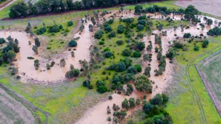
Floods can create dangerous conditions that put communities at risk. Flood hazard classifications help us understand floodwaters’ potential for harm and property damage, based on their behaviour – like depth and speed.
How classifications are determined
Flood hazard classifications range from H1 to H6. H1 represents the lowest level of hazard, and H6 the highest.
Classifications are based on factors like:
- how deep floodwaters might get
- how fast floodwaters could flow
- how quickly floodwaters might rise
- how much warning time people might have
- whether people could become isolated.
| Classification | Characteristics |
|---|---|
| Hazard 1 |
Flooding is this area is usually minimal and tends to affect roads, gardens and other low-lying areas. Floodwater is typically shallow – up to 300mm deep – and unlikely to cause much damage or pose a safety risk. Because of this, the flood hazard is considered low, and the area is generally safe for people, vehicles and buildings. Most types of development, including new homes and subdivisions – are suitable here with suitable design considerations. However, essential community services like hospitals may need extra consideration before being built in these locations. |
| Hazard 2 |
Flooding in this area can reach depths of up to 0.5 metres, which may pose a risk to small vehicles. While the floodwater is generally safe for able-bodied people, it can still be unpredictable and should be treated with caution. This is why the area is considered to have a medium flood hazard. New commercial and industrial buildings are usually suitable in these areas, but some housing may not be safe even if designed with flood protection in mind – like raised floor levels and safe access. These areas are not appropriate for increasing housing densities without appropriate flood protection measures. Thoughtful planning and design help make sure new development is safe and suitable for the area. |
| Hazard 3 |
Flooding in this area can reach depths of up to 1.2 metres. The water flow may be strong and could pose a risk – especially to children, older residents, and those needing extra support. Because of these conditions, the area is classed as a medium flood hazard. Building or renovating here requires careful planning. Land may still be able to develop but needs to be located/sited to avoid areas of higher hazard and designed with flood protection in mind. New buildings or subdivisions are discouraged without appropriate flood protection measures. |
| Hazard 4 |
Floodwaters in this area can be fast-moving and deep, with depths of up to 2 metres. These conditions make the area unsuitable for people and vehicles during flood events. Because of the high flood hazard, any new use of the land should be carefully considered, and dense development is not recommended. New buildings or subdivisions are discouraged. Areas such as parks or public open spaces are suitable. |
| Hazard 5 |
Floodwaters in this area can be very deep up to 4.0 metres – and may damage or destroy most types of buildings. Because of this, it is not a safe location for development. These areas are important for natural flood flow and flood storage, which help protect other parts of the community. The flood hazard is high and no intensification of land use or new buildings should occur. Prioritise the safety of the community and protect the environment. |
| Hazard 6 |
Flooding in this area can exceed 4.0 metres in depth, making it unsuitable for any buildings or development and makes the flood hazard in this zone high. These areas are critical for flood management and should remain untouched. Let the land perform its natural flood-control role. Prioritise the safety of the community and protect the environment. |
Why flood behaviour matters
The behaviour of floodwaters directly affects the vulnerability of people, buildings and communities during a flood.
Understanding the full range of potential scenarios helps locals and authorities make informed decisions about safety, planning and development.
- Hazard 1 (H1): Sarah
-
Sarah rents a cosy home with her partner and their two energetic dogs, far from a river or creek. She had never given much thought to flooding, always assumed the drains would prevent it.
After exploring Melbourne Water’s online flood maps, she discovered her street is prone to flooding during major storms – potentially affecting her car parked outside. Her area is classified as H1: indicating it’s appropriate for residential living but still carries some risk.
Sarah’s now better equipped to plan ahead. She’s even thinking of ways to adjust her routine to protect what matters most, including her home, her pets and that trusty car out front.
- Hazard 3 (H3): Van
-
Van lives in a suburb where flooding has become increasingly unpredictable due to changing weather patterns.
When reviewing flood maps online, Van discovered that their property is classified as H3 and located within the path of overland stormwater flows. This means that floodwaters can be deeper and move faster than expected, posing a greater risk to homes and infrastructure.
For Van, this new information has been eye-opening. It’s helped them understand how floodwaters behave in their neighbourhood, and how to make informed decisions about protecting their property – especially as they begin planning renovations.
- Hazard 5 (H5): Jason
-
Jason lives with his family on a large block of land next to a creek. He loves living there – especially riding his bike to work along the creek. He always knew the creek could flood, having seen the bike path underwater before. But he didn’t realise that his own backyard was at risk.
That changed when he looked into updated flood maps for his area. He saw that although his house is in a safer spot near the road, his backyard slopes down to the creek, where floodwater can be deep and fast-moving. His house is not in the highest-hazard zone, but parts of his backyard are.
Now that Jason knows how floodwater could affect his property in a big storm, he’s thinking ahead. He’s planning what he can do to keep his family and property safe.
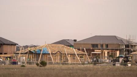
Planning and building implications
Flood hazard classifications can guide where and how development occurs, so projects meet safety and environmental standards.
Higher hazard areas attract stricter planning controls and building requirements to protect people, property and infrastructure. Lower hazard areas allow for compatible development, with streamlined approvals and targeted safeguards. Development in certain areas may be subject to restrictive controls unless drainage infrastructure is upgraded to enable development.
You can use flood hazard to understand what development is allowed on your property.
- Hazard 1 (H1): Sarah
-
Sarah’s home is in a H1 hazard area. That means her land can be impacted by shallow, slow-moving floodwater.
Most types of residential development are suitable in her area. However, her council and Melbourne Water still need to confirm that any changes won’t affect local drainage or the path of overland flows.
Ensuring that new buildings meet key requirements – such as minimum floor heights and building setbacks – avoids increasing flood risk for Sarah and her neighbours.
- Hazard 3 (H3): Van
-
Van’s property is partly located within a H3 flood hazard area, meaning that some parts of their property may be exposed to deeper and faster-moving floodwater during heavy rainfall.
As Van begins planning a home extension, they’re learning that buildings in flood-prone areas must be carefully designed. They may need raised floor levels or building setbacks so floodwaters can flow safely through the property. Some areas with high flood risk may not be suitable for development at all.
Van is working with their council and Melbourne Water to understand what is permitted and what adjustments may be needed, so their development plans can be approved – and resilient to future flooding.
- Hazard 5 (H5): Jason
-
Jason owns a property in a H5 flood hazard area, where floodwaters can be deep, fast-moving and dangerous. His land slopes towards a creek, so while his house is not in the highest-hazard zone, parts of his backyard are. These play a critical role in a flood – storing floodwaters and providing a natural path for overland flows.
Because of the high hazard classification, Jason’s property has limited opportunities for further development. Certain parts of his land must remain open to allow water to flow through safely. Building there would not only be unsafe, but is unlikely to be permitted under planning regulations.
Jason understands the importance of planning with future flood risk in mind. He’s aware that protecting these natural flow paths helps protect not just his home, but also the broader community. Rather than pursuing major development, Jason is focused on maintaining the integrity of his property and staying informed about flooding in his area.
You may also like...
Prepare for flooding
By understanding your flood risk and taking a few simple actions, you can be prepared for flooding.

Flooding information and advice
Plan ahead. Understand the impacts of potential flooding on your plans to buy, sell, build, renovate or develop.
Flood planning controls explained
There are four types of flood planning controls where you may need our consent before your council will issue a planning permit.

Building and home renovation
Before you start building, renovating or sub-dividing, make sure your plans meet our criteria for flood, water asset and waterway protection.