The heritage-listed Maroondah system has been supplying Melbourne with clean drinking water since 1891. Explore its past and present with virtual tours and video series.
Located northeast of Melbourne, the system includes Maroondah Aqueduct, Coranderrk Aqueduct and Maroondah Reservoir. While some sections have been decommissioned, many still play a key role in the everyday supply of water – and several areas are open to the public for picnics and walking.
Tour the Maroondah system
Experience key locations and discover the history behind them, with our 360-degree panoramas:

Maroondah Aqueduct
Journey from the reservoir outlet tower to Yering Gorge Pumping Station, through Donnelly’s Weir – a popular picnic spot – and One Lane Bridge.

Coranderrk Aqueduct
Follow the aqueduct from Badgers Creek Weir to Silvan Reservoir, and learn how it was maintained by hearing first-hand from a previous caretaker.

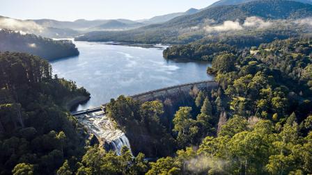
Maroondah Reservoir
Admire the scenic garden and picturesque valve houses at the base of the dam, and take in views over the reservoir and its outlet tower.
How the system works
Aqueducts are channels that carry water from one place to another. In the past, Maroondah and Coranderrk aqueducts transported water from Watts River and Graceburn and Badger creeks, which in turn are fed by densely forested catchments – often in the form of National Parks.
Nowadays, Maroondah Aqueduct is fed by Maroondah Reservoir: a large water storage formed by building a dam across the Watts River. From the aqueduct, water flows through pumping stations, siphons and tunnels on its way to Melbourne.
Historical timeline
The Maroondah system’s history is inextricably linked with Melbourne’s expansion and development. This incredible infrastructure exists thanks to the hard work of the men and women who built and maintain it, with each section representing a major feat of engineering.

1870: Demand for water outstrips supply
Following the gold rush, sustained population growth and a dry decade placed pressure on Melbourne’s only reservoir – Yan Yean – which had shrunk to low levels by 1879. Demand for water again became a concern, and the search for a new source of clean, abundant and reliable water was on.

1879: Survey of Watts River completed

The Water Supply Board (predecessor to the Melbourne Metropolitan Board of Works) commissioned surveyor J.H. Davies to undertake a detailed survey of the Watts River and its tributaries. Davies reported that the area was viable and suggested two options: a diversion weir, or a dam across the Watts River valley.
1886: Watts River Scheme construction begins
The Water Supply Board decided to build a weir upstream from the proposed dam site, diverting water from the Watts River to Preston Reservoir via an open aqueduct. This came to be known as the Watts River Scheme.

Watts River and its tributaries were assigned exclusively as water harvesting catchments, and the area was closed off to human occupation to protect water quality. This meant relocating the entire township of Fernshaw, which had been established along the river as a coach stop in the 1860s.
1891: Melbourne Metropolitan Board of Works established

The Watts River Scheme was completed in February 1891 and renamed ‛Maroondah’, on the false assumption this was the Indigenous name for the area. Coinciding with its completion, the Melbourne Metropolitan Board of Works (MMBW) was formed one month later on 18 March 1891.
The MMBW was tasked with building a much-needed sewerage system to tackle the typhoid and cholera epidemic gripping Melbourne, but its functions were soon expanded to include managing Melbourne’s water supply system.
1909: Coranderrk system completed

The MMBW continued work on the Maroondah system, commencing work on the Badger Creek Weir in 1905 to connect to the Graceburn-Maroondah aqueduct siphon. Upon completion in 1909, the system was named ‛Coranderrk’ after the nearby reserve established by the Wurundjeri people. The Coranderrk Aqueduct was added to the system in 1931.
The same year, a Royal Commission was held to decide between building a reservoir at Maroondah or a diversion weir on the O’Shannassy River. While also recommending the O’Shannassy scheme, the Commission acknowledged the need for Maroondah Reservoir to meet growing demand.
1920: Maroondah Reservoir construction begins
")
Further population growth and a severe drought prompted the MMBW to begin building its first water supply project, the Maroondah Dam. The dam was built downstream of the original Watts River weir and completed in June 1927. Thereafter, the Watts River Scheme became known as the Maroondah Water Supply System.
1920 onwards: System expansion
The MMBW further expanded the water supply system throughout the 1920s and 30s, building the O’Shannassy and Silvan reservoirs to increase Melbourne’s water storage capacity from 30,000 megalitres to 104,500 megalitres.
Development continued into the second half of the twentieth century, with major projects including the Upper Yarra, Thomson and Sugarloaf reservoirs.
2018: Heritage listing
The Maroondah Water Supply System was added to the Victorian Heritage Register, affirming its rightful place in Victoria’s history and Melbourne Water’s place in community.
You may also like...
Maroondah Reservoir
View facts and historical rainfall data for Maroondah Reservoir, which supplies Melbourne’s northern, western and inner suburbs.