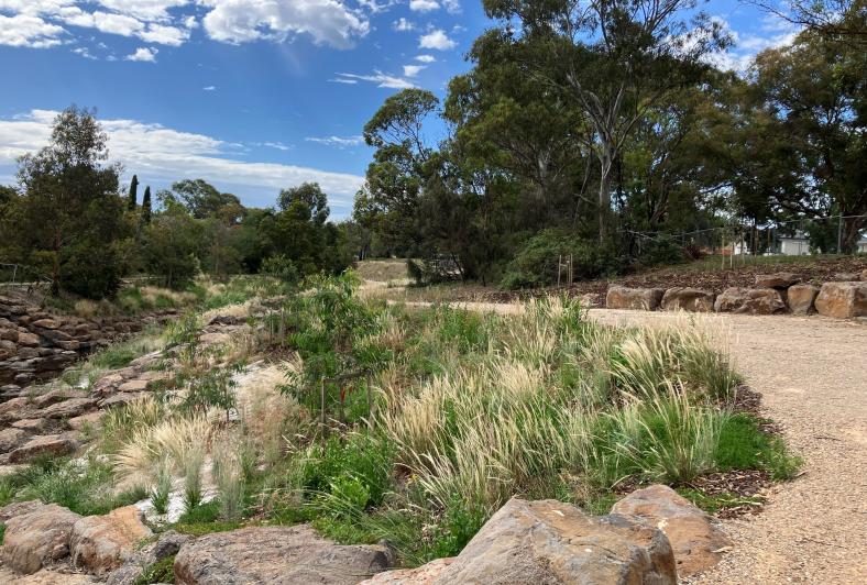
The Reimagining Moonee Ponds Creek project is transforming a section of your much loved creek in Strathmore and Oak Park into a more naturalised waterway.

Artist's illustration of Moonee Ponds Creek with a pond at Oak Park, naturalised waterway, terraces and daylighting of the drain.
Artists impression - Reimagining Your Moonee Ponds Creek

In 2021, you told us what you love about Moonee Ponds Creek, how you use the space, and what future improvements were important to enhance the creek channel and make the surrounding area a more desirable open space for the community to enjoy. We used your feedback to develop three design concepts to revitalise the creek environment, and you voted on your preferred concept design. We are now working to turn that concept design into a reality! 

Read how the project design was developed 

Melbourne Water is leading the delivery of the project on behalf of the Chain of Ponds Collaboration Group and in partnership with Merri-bek City Council, Moonee Valley City Council, Department of Energy, Environment and Climate Action (DEECA), Greater Western Water, and Wurundjeri Woi Wurrung Cultural Heritage Aboriginal Corporation.

What we’re doing

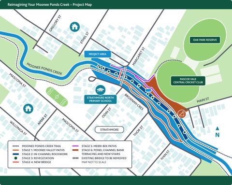
Reimagining Your Moonee Ponds Creek project map. Click to enlarge.

A 360-metre section of the concrete-lined Moonee Ponds Creek is being transformed into a more natural, enjoyable community space. We’re doing this by:

  • removing the concrete walls along both sides of the creek and replacing this with rockwork
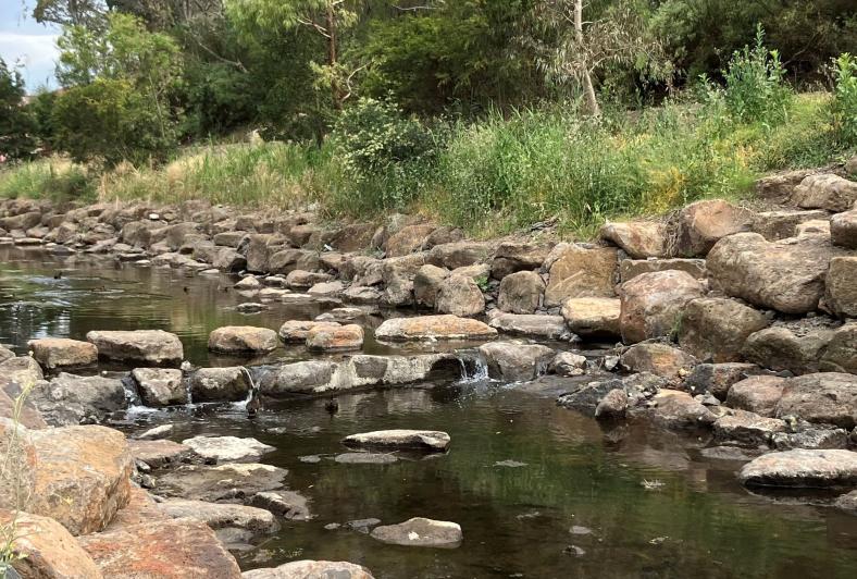
  • covering the concrete base of the channel with rockwork to create a meandering creek, to slow down flows and give it a more ‘natural’ look and feel
  • planting 43,000 native trees and shrubs 
  • creating new shared paths and a new bridge 
  • constructing a pond and terracing near Oak Park Reserve.

A cultural immersion trail along this section of creek will also be created. This experiential trail will highlight the cultural and natural values of the waterway, and celebrate Moonee Ponds Creek as a place owned, lived in and celebrated by Wurundjeri people. Using a mixture of signage, art and digital media, the project will invite trail users and the community to learn from Elders and knowledge holders about aspects of Wurundjeri culture and history, and encourage people to become better connected and care for Country.  

The re-naturalisation works will result in:

  • a more appealing creek-side environment where people can interact with nature in a cooler, healthier environment
  • improved water quality and waterway health by slowing water flows
  • improved biodiversity and habitat for native species
  • activation of open space and better active transport connections for improved community use and recreation in the area.

Project timeline and progress

Construction works started in early 2023 and are expected to be complete late 2024. 

Watch progress from September to December 2023, as we replaced the concrete walls and covered the base with rockwork to create a meandering creek with a more natural look and feel. Not only will this create a more appealing environment where people can interact with nature - it will also improve water quality and waterway health by slowing down water flows.

Reimagining Your Moonee Ponds Creek: September-December 2023 timelapse - transcript

Complete
 

Stage 1: Moonee Valley Council shared paths

May 2023 to February 2024

New shared path along Brosnan Crescent

The new Brosnan Crescent concrete shared path (Moonee Valley Council side) is now open. We'll be installing safety fencing along some sections of this path over the coming months.   

A new gravel path along the southern bank of the creek is now complete, however we need to keep this closed until the earthworks in this area are complete.

Complete
 

Stage 2: In-channel rockwork

January 2023 to February 2024

Rockwork in the Moonee Ponds Creek channel in low flows

After some delays caused by wet weather and high flows in the creek in January 2024, the in-stream channel rockwork is now complete. It was a slow and meticulous process to place the rocks in such a way to make it look as 'natural' as possible.

Started
 

Stage 3: Revegetation of creek channel banks

May 2023 to September 2024

Native grasses, shrubs and trees planted along the creek banks (June 2024)

Native shrubs recently planted along the creek-side (August 2023)
Native grasses planted along the creek banks (August 2023)
  • The planting of more than 43,000 native trees, grasses and shrubs will be completed in a staged manner. While some have been planted, most of the revegetation will be done after the hot summer months to ensure we give the plants their best chance of survival. 
  • We planted almost 200 aquatic plants on the bottom of the creek channel in December 2023. 
  • We have planted roughly 17,000 native plants since the start of the project. The majority of the species being native grasses. 
  • Revegetation will continue through to the end of 2024.
Not Started
 

Stage 4: Construction of new bridge

Late September 2024

Due to delays with the design, the bridge will now be installed in late September. Works have been completed in May for the footings and abutments.

Started
 

Stage 5: Construction of Merri-bek shared paths

March 2024 to October 2024

The shared path on the northern side of the creek will be one of the last activities to be completed, after the pond and terracing works are finished (October to November 2024).

Started
 

Stage 6: Construction of pond, channel bank terracing, and new stairs

December 2023 to November 2024

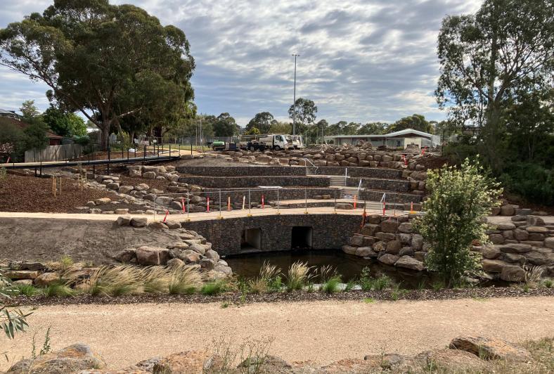
Construction of pond and terracing in progress - Merri-bek Council side of creek
Construction of pond and terracing in progress

Construction of pond and terracing is in progress - Merri-bek Council side of the creek.

Construction is continuing to put the ‘pond’ back into the Moonee Ponds Creek, along with works to create stepped terracing (like a natural amphitheatre) on the creek banks. This is an exciting part of the project where we’re making better use of open space by creating public gathering spaces for the community to enjoy. These works are happening on the Merri-bek Council side.

This is one of the most complex activities that we’re delivering as part of the project. We expect these works to be complete by the end of November 2024.

Started
 

Cultural immersion trail

Wurundjeri Woi-Wurrung Cultural Heritage Aboriginal Corporation are continuing to work with the Chain of Ponds Collaboration and design consultant Kelp Creative to create an experiential trail along the banks of the creek. The trail will highlight the cultural and natural values of the waterway, and celebrate Moonee Ponds Creek as a place owned, lived in and celebrated by Wurundjeri people.

Using a mixture of signage, art and digital media, the project will invite trail users and the community to learn from Elders and knowledge holders about aspects of Wurundjeri culture and history, and encourage people to become better connected and care for Country.

Design of the trail is underway and construction is expected to be completed by November 2024. This part of the project is supported by the Department of Energy, Environment & Climate Action (DEECA) through the Port Phillip Bay Fund.

What to expect

While we will make every effort to ensure inconveniences are kept to a minimum, there will be some local impacts:

New shared-use bridge installation

Temporary pedestrian closures and detours will be in place to ensure public safety, while we install the new shared-use bridge connecting Odin and Margaret streets. The new bridge is expected to open on 11 October, weather permitting.

Thursday 3 October, 5pm

The new bridge will be opened.

What to expect:

  • The existing bridge will be closed.
  • Pedestrian detours will be in place via the Oak Park Reserve, Main Street and Moonee Ponds Creek Trail.
  • Beware of heavy vehicles using local roads.
  • Noise is expected from construction machinery, vehicles and equipment.

Pedestrian detour via Oak Park Reserve, Main Street, Moonee Ponds Creek Trail and pedestrian bridge near Lebanon Reserve.
Pedestrian detour map
Friday 18 October, 10am to 3pm

The existing bridge will be removed.

What to expect:

  • The existing bridge will be removed.
  • Pedestrian detours will be in place via the Oak Park Reserve, Main Street and Moonee Ponds Creek Trail.
  • Traffic controllers will stop traffic on Winifred Street while trucks are reversing and guide pedestrians.
  • Beware of heavy vehicles using local roads.
  • Noise is expected from construction machinery, vehicles and equipment.

Pedestrian detour via Oak Park Reserve, Main Street, Moonee Ponds Creek Trail and pedestrian bridge near Lebanon Reserve.
Pedestrian detour map

Thank you for your patience while we carry out these works.

Path closure – Pedestrian path from Margaret St to Oak Park Reserve 

The path from Margaret Street to Oak Park Reserve will be closed in October to complete the boardwalk and new path. Temporary access is via Margaret Street and Main Street. For your safety please follow the detour route via the signs.

Shared path detours

For the safety of everyone, some shared paths will be closed during the works. Pedestrians and cyclists will be detoured along Mascoma and Odin Streets for the entire project (please see the detour map). Thank you for your patience and understanding of these short-term inconveniences as we work to improve your shared path network. 

Traffic changes

  • Construction vehicle traffic: there will be an increase in large vehicle movements in the local area as materials and equipment are delivered for the works. Construction access is via Main Street for the channel works and concrete trucks will be visible on Brosnan Crescent for the shared path works. 
  • Traffic management will be in place to ensure access to local streets and properties is maintained at all times throughout the project.

Parking

  • For heavy vehicles to access the works area, there will be temporary changes to parking, including the removal of parking along the north side of Main Street between 7am-4pm on weekdays. Parking will remain available on the south side of Main Street.

Noise

  • A site compound is located at the corner of Main Street, next to the Oak Park Reserve. This will remain here for the whole project.
  • Noise is expected from construction machinery, vehicles and equipment. A bypass pump will be in place during the installation of in-stream rockwork (on the bottom of the creek channel) to divert water around the works zone. The pump needs to run on a continual basis, and there will be some noise from this. We are very mindful of the pump's location in a residential area, and we have made every effort to install the most effective noise-reducing measures around it as we can. We'll also turn off the pump when site conditions allow, and when it’s not needed for our activities.   

We thank you for your patience and cooperation while we carry out these works.

FAQs

Why was the creek lined with concrete?

Between the 1940s and 1980s, like many urban waterways, the Moonee Ponds Creek from Strathmore to Flemington Road was highly modified, realigned and concreted by the Melbourne and Metropolitan Board of Works (MMBW), to carry flood water away from properties in the most efficient manner possible – which was considered best practice at the time.

Waterway management and drainage approaches have evolved over time to better recognise the environmental and social value of natural waterways, and for these values to be managed in harmony with the drainage services they also provide. Current thinking now better recognises the value that restoring previously engineered stormwater channels to more natural systems (creek naturalisation) contributes to liveable communities and waterway health.

Why was this section of Moonee Ponds Creek chosen to ‘reimagine’ over other sections?

The Reimagining Moonee Ponds Creek project covers a 360-metre section of the most northerly concreted section of the creek in Oak Park and Strathmore. Through community feedback that informed the Chain of Ponds Strategic Plan in 2018, this particular section of the creek was identified as a priority area as it was the last section of the creek to be concreted, and represents the most upstream section of concrete channel.

Why is only a 360 metre section of creek being naturalised?

The naturalisation of large concrete channels like Moonee Ponds Creek can unfortunately be very costly. This is primarily due to the significant excavation required to remove the concrete and reshape the waterway to recreate a more natural form, making strong delivery partnerships essential in the delivery of large naturalisation projects. This project was also a pilot to demonstrate how Moonee Ponds Creek could be naturalised more cost-effectively in the future, so it was important to start small.

Why can’t all the concrete be completely removed?

Due to low levels of PFAS in the soil beneath the concrete base of the creek channel (something we discovered during preliminary investigations for the project in 2021), a decision was made to leave the concrete base in place, essentially locking the PFAS in the soil. This decision was mainly based on the high additional costs associated with the transport and disposal of contaminated soil off site at a designated waste management facility, and making the best use of the funds we have.

By installing rockwork on top of the concrete base, rather than removing the concrete, a similar ‘naturalised’ look will still be achieved.

What is PFAS – is it harmful?

PFAS (per-and polyfluoroalkyl substances) are a group of manufactured chemicals. All of us are exposed to small amounts of PFAS in everyday life. This is through exposure to dust, indoor and outdoor air, food, water, and contact with consumer products that contain PFAS, such as clothing, carpets and non-stick cookware. In the past, fire-fighting foams also contained PFAS. There are low levels of PFAS in soil, sediment, water and animals across most of Victoria. This is unlikely to be harmful to human health, and recent studies show people's exposure to PFAS in the general environment is reducing. However, there are still many unknown factors about how PFAS affects human health. This is why the Environment Protection Authority (EPA) takes a precautionary approach and advises Victorians to take care and reduce their exposure to PFAS.

What’s being done with the concrete that’s removed?

Upon testing, it was revealed that soil in the project area contains fragments of non-friable asbestos. Non-friable asbestos is lower risk compared to other types of asbestos as it is more difficult to become airborne. In line with contamination handling guidelines, a licenced contractor wearing recommended safety equipment will undertake the removal to ensure that the risk remains negligible. While not required by regulations, Melbourne Water will take a conservative approach and engage a health and safety consultant to monitor air quality in the area to ensure that it remains at safe levels to the public.

Are there future plans to naturalise more sections of Moonee Ponds Creek?

The Chain of Ponds Collaboration Group sets a long term strategic plan to progressively transform Moonee Ponds Creek into an iconic waterway for Melbourne that provides high social, cultural and environmental benefits.

The Collaboration has developed a prospectus identifying a number of priorities for advocacy and delivery. Working groups have been established around these priorities, determining ways to deliver projects using a catchment-wide approach. More information on key projects that are currently underway can be found here: https://chainofponds.org/

It is envisaged that if the Reimagining Moonee Ponds Creek project is successfully delivered and shows a good return on investment with strong community support, that this will help to leverage funding for naturalising other sections of the creek in the future.

What about asbestos?

Upon testing, it was revealed that soil in the project area contains fragments of non-friable asbestos. Non-friable asbestos is lower risk compared to other types of asbestos as it is more difficult to become airborne. In line with contamination handling guidelines, a licenced contractor wearing recommended safety equipment will undertake the removal to ensure that the risk remains negligible. While not required by regulations, Melbourne Water will take a conservative approach and engage a health and safety consultant to monitor air quality in the area to ensure that it remains at safe levels to the public.

Reimagining Your Creek Program

Melbourne Water’s Reimagining Your Creek Program works collaboratively with councils, communities, Traditional Owners and local residents to transform stormwater drains and concrete channels into natural waterways and desirable open spaces.

The program has seen the transformation of sections of Taralla Creek in Croydon, Arnolds Creek in Melton West, and Blind Creek in Boronia. Works are currently in progress for the program’s biggest project along Blind Creek from Scoresby Road to Lewis Park in Wantirna South.

Comprehensive flood modelling is always undertaken to ensure that there will be no increased flooding risk to the local community or downstream users as a result of these projects.

Community bulletins

Contact us

If you have questions or feedback on the project, please get in touch with the project team:
 1800 952 911

 [email protected]

Last updated: