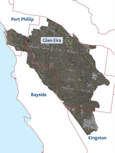
Melbourne Water is working in partnership with the cities of Bayside, Glen Eira, Kingston and Port Phillip to take a holistic approach to reducing flood risk in Elster Creek Catchment, collaboratively implementing the Elster Creek Catchment Flood Management Plan 2019-24.
Why this is important
The Elster Creek Catchment has always been prone to flooding. Climate change and increasing urban development will add to these challenges, with more severe and frequent storms and more hard surfaces like roofs and roads generating more stormwater runoff.
Despite our efforts to minimise flooding, it cannot be completely eliminated. The plan therefore contains a range of interventions to reduce flood risk, including building community understanding and preparedness.
Plan overview
The Elster Creek Catchment Flood Management Plan outlines a five-year program of works that builds on previous investments to reduce flood risks across the catchment.
It was developed in close consultation with councils and the local community, focusing on three key areas to ensure a holistic approach to flood planning in the catchment:
- implementing on-ground solutions that minimise flooding and its impact on the community
- influencing development across the catchment to minimise run-off and reduce flood risk
- ensuring the community is informed, actively engaged and understands the challenges of managing flooding in the catchment and what is being done about it.
Project partners are committed to cooperating across council boundaries to implement the plan, and working with water utility companies, the Victorian Government and the community.
Download the full Flood Management Plan and the partner memorandum of understanding:
What’s happening and when
View the latest progress on actions within the plan, grouped by focus area, and stay informed of opportunities to get involved.
Plan implementation status
- One catchment, many solutions
-
Action Delivery Lead agency % Complete Plan to incorporate increased flood mitigation within Elsternwick Park precinct in conjunction with development of Elsternwick Park Nature Reserve.
Jul ‘19 – Dec ‘22 Bayside City Council & Melbourne Water 80%
Business case approved; detailed investigations and engineering design underway; ‘liveability’ design and partner and community consultation upcoming
Seek opportunities to identify new or expanded physical works (including retarding basins) on public land across the catchment.
Develop an implementation plan for identified projects.Jul ‘19 – Jun ‘24 Melbourne Water & Glen Eira City Council 100% complete
Investigations have identified one option – potential construction of a pipeline from Koornang Main Drain to Port Phillip Bay – that will be further investigated, commencing 2023/24.
Other projects that will have flood mitigation benefits are progressing outside of this plan, including the Elwood Main Drain Duplication Project and Elsternwick Park Masterplan.
Incorporate flood mitigation into all council and Melbourne Water capital projects within the catchment where feasible. Jul ‘22 – Jun ‘24 Local Government & Melbourne Water 50%
Consideration of flood mitigation opportunities is incorporated within the relevant procedures and processes for capital works projects.
Undertake research on suitable permeable surfaces for the Elster Creek Catchment and develop a tool which can be used to measure and compare permeable treatments. Jul ‘19 – Jun ‘20 City of Port Phillip 100% complete
Investigate incentives or funding mechanisms for landholders to reduce impacts on local catchments by reducing runoff and increasing permeability. Jul ‘20 – Jun ‘22 Melbourne Water 100% complete
Melbourne Water commissioned E2DesignLab to develop a permeability investment decision-making framework, including incentives. Potential pathways to implement will be considered alongside permeability target setting discussions (Deliverable 9).
Develop and implement a strategic advocacy approach to the Victorian Government and other organisations to:
- Prioritise flood mitigation in the development of strategic sites and urban renewal areas
- Encourage schools (public and private) to install water recycling infrastructure
- Encourage schools (public and private) to include flood mitigation within school open space.
Jul ‘19 – Jun ‘24 City of Port Phillip & City of Glen Eira 50%
Joint advocacy statement developed and utilised for 2022 State Election; to build upon following election
- Land use planning
-
Action Delivery Lead agency % Complete Seek authorisation from the Minister for Planning to prepare a planning scheme amendment to update the extent of the Special Building Overlay (SBO) to reflect more recent flood mapping data within Glen Eira. Jul ‘19 – Jun ‘21 Melbourne Water & Glen Eira Council 75%
Updated modelling incorporating new climate change projections largely complete. Council and MW to review model, understand impacts and then Council can prepare authorisation.
Establish a flood baseline and set flood risk reduction targets within the Elster Creek Catchment. Jul ‘20 – Jun ‘22 Glen Eira City Council 75%
Baseline established for Glen Eira municipality as part of IWM Plan. Target setting discussions on hold until after SBO deliverable (D7) completed.
Establish a catchment baseline for permeability and set targets to increase permeability in both the private and public realm. Include consideration of future development into permeability target setting. Jul ‘20 – Jun ‘22 Glen Eira City Council 60%
Baseline incorporated into Glen Eira IWM Plan; to build targets from this baseline.
Consider options for implementing an offset trading scheme across the Elster Creek Catchment where funds can be collected from developers to fund drainage infrastructure works in another location. Jul ‘22 – Jun ‘24 Glen Eira City Council 100% complete
Analysis and options paper presented to council CEOs; offsetting for volume not feasible.
Investigate the development of a Catchment-wide Development Contributions Plan Overlay into the planning scheme for each of the four councils. Jul ‘22 – Jun ‘24 Glen Eira City Council 100% complete
A DCP is not recommended due to insufficient projected growth and lack of substantial pipeline of feasible infrastructure opportunities.
Share information and build capacity of council staff to effectively and consistently implement the Victorian Planning Provisions for Stormwater Management in Urban Development (Clause 53.18). Jul ‘19 – Jun ‘24 City of Port Phillip 80% - Informed and well-prepared communities
-
Action Delivery Lead agency % Complete Develop a Communications and Engagement Plan that addresses the following:
- Builds community awareness about the catchment and flood overlays
- Builds community preparedness for flooding
- Links with Emergency Management to educate the community about how to respond in times of flood
- Educates the community on changes they can make to their properties to increase resilience to flooding
- Demonstrates the funding commitment from project partners
- Uses simple, plain English and real world relatable examples
- Is delivered in a way that reaches different sections of the community (renters, owners, businesses, etc.)
- Annual awareness campaign targeted at wider community about flood risk and vulnerability
Jul ‘19 – Dec ‘19 City of Port Phillip 100% complete
Coordinate delivery of the Communications and Education Plan Jan ‘20 – Jun ‘24 City of Port Phillip 70%
Include collaboration on education and communications programs with key stakeholders and community champions in the Communications and Education Plan (above action), including:
- Port Phillip EcoCentre
- State Emergency Service
- South East Water
Jul ‘19 –Dec ‘19 City of Port Phillip 100% complete
Transitioned to an ongoing action
Review form and function of the Community Reference Group including membership, purpose and meeting frequency.
Jul ‘19 – Dec ‘19 Melbourne Water 100% complete
Development of a pilot program that provides a tailored approach to flood awareness, education and response (with potential higher levels of services) based on sub-catchment flood risk profiles.
Jul ‘19 – Jun ‘20 Melbourne Water 100% complete
Work with Emergency Management Victoria, State Emergency Services, Department of Environment, Land, Water and Planning and the Bureau of Meteorology to improve coordination and response to major flood events, including:
- Scenario planning and alignment of Municipal Emergency Management Plans
- Communications after flood events
- A mechanism (such as a mobile app) for impacted communities to update flood impacts during and post flood.
Jul ‘19 – Jun ‘24 Melbourne Water 75%
Agency coordination and communication during and following flood events has been improved.
Improved accessibility to information about flood events is a focus of discussions between Melbourne Water, State Emergency Services, Emergency Management Victoria and the Bureau of Meteorology.
Develop an online resource for residents and businesses to find information related to flood risk, how to prepare and what they can do to make their homes more flood resilient.
Jul ‘20 – Nov ‘21 Melbourne Water 75%
Information about how to prepare for and make homes more flood resilience has been developed. Online mapping is now available to the community as part of the Victorian Government’s Digital Twin project.
Investigate and invest in partnerships with the insurance industry.
Advocate to the insurance industry to share information with the community and to reduce insurance premiums for properties that are more resilient to flood impacts.Jul ‘19 – Jun ‘24 Kingston City Council 40%
Last action status update: January 2024
Contact us
If you have feedback or would like more information about this project, contact us.
Related links
Koornang Main Drain investigations
In partnership with Glen Eira City Council, we’ve commissioned several studies into options for mitigating flooding from the Koornang Main Drain, which services the suburbs of Ormond and McKinnon.
Elwood Main Drain Duplication
Keep up to date with this project, which was developed from an investigation into flood mitigation options in and around Elsterwick Park - a key initiative under this flood management plan.
Flooding
It's an inevitable part of Melbourne’s weather cycle, but we aim to minimise the risk to people, property and infrastructure.
Flood Management Strategy for Port Phillip and Westernport
Learn more about the strategy, currently being refreshed and due to take effect mid-2021.
Retrofitting your home for flood resilience
In May 2021 community were invited to attend a free online information session to learn about the new Flood Resilient Guide to Retrofitting Your Home.


