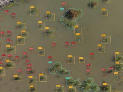
Artificial intelligence has been used with drone imagery to detect vegetation in retarding basins, potentially reducing monitoring costs to ensure they meet design requirements. Read the case study to learn more.
Sustainable Development Goals:
Goal 11: Sustainable cities and communities
Goal 15: Life on land
Background
We manage more than 200 retarding basins across Greater Melbourne, with another 40 to be added by the end of 2021. These low-lying areas of land are vital for reducing flooding, and are reserved for the purpose of storing heavy rainfall.
Retarding basins must meet minimum design requirements, meaning it’s critical we monitor the vegetation health of both newly-established and existing basins. We currently monitor using both random sampling and on-the- ground fieldwork.
Research focus
Our recent development of unmanned aerial vehicle (UAV) capabilities has provided a unique opportunity for a more comprehensive and cost-effective way to monitor vegetation in retarding basins. This can replace the manual counting methods used for many years.
In partnership with FrontierSI, a not-for-profit spatial data research organisation, we’ve used machine learning to develop a prototype algorithm for ‘deep learning’ tree detection and vegetation counting.
The algorithm can assess the presence or absence of vegetation, identify the type of vegetation and the number of different areas of vegetation. It is proving successful in interpreting retarding basin images captured by UAVs.
Outcomes
The prototype aims to establish the viability and confidence we can place in the algorithm, which could potentially reduce the high cost of vegetation monitoring in retarding basins.
With recent major machine learning breakthroughs significantly reducing error rates, the technology is now better than the human eye at detecting features in UAV photographic images.
You may also like...
Delivering on the Sustainable Development Goals
This report outlines Melbourne Water's unwavering commitment to advancing sustainability through the United Nations Sustainable Development Goals (SDGs).


